Why Old Streets Rarely Follow a Neat Grid
Why old streets rarely follow a neat grid: read slopes, bends, and former paths to understand an unfamiliar district and choose a calmer way through.
The common mistake in an old district is treating every bend as a wrong turn. That can cost you time and obscure clues about where you are. Why old streets rarely follow a neat grid becomes clearer when you read the slope, the routes people already use, and the buildings that shape the streets around them.
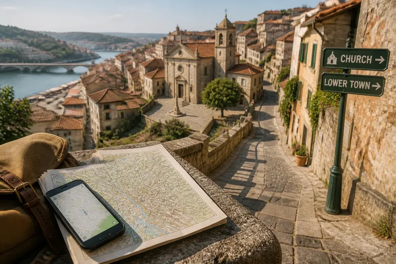
Imagine you arrive in the invented hill town of Bellacosta with a paper map and a phone map that give different street names. You plan to walk from the bus station to a riverside market, then find a viewpoint above the center. The direct-looking route climbs sharply, lanes split near a church, and a street that appears to continue on the screen ends at steps. The useful shift is simple: notice what the ground and landmarks tell you before choosing a turn.
Read the slope
Compare the map with what your feet tell you. On a hillside, streets may run across the slope, then connect by steeper lanes, ramps, stairs, or switchbacks. A pattern that looks indecisive on a flat screen may follow a shelf of land or gain height gradually.
In Bellacosta, a straight line points toward a steep lane, while a longer road curves along the hillside. The line is shorter, but distance alone does not tell you how the walk will feel or whether the route is passable. If the map shows contour lines, use them to compare the ground; also look for streets that run across the hill rather than directly uphill.
A road that bends around a ridge may keep to a more even level. Steps can connect two tiers of streets directly, but may be tiring with luggage or unsuitable for wheels. A broad road around the high ground may be less direct and easier to follow.
Choose according to the day you are having. With a bag, tired legs, or unsettled weather, a gentler contour route may make more sense. If you are moving lightly and want the climb, steps may suit you. Ask not only which way is shortest, but which kind of effort you are willing to spend.
Trace older paths
Some streets bend because they began as paths. They may have connected a water source, meeting place, farmland, bridge, or neighboring settlement. As buildings gathered beside them, the paths widened or gained new names without losing their original direction.
On a map, an older route may look like a narrow, irregular lane connecting useful places rather than forming a block. It might run from a gate toward a bridge or link a market street with a churchyard. That shape does not prove a particular history. It gives you a reason to ask what the route connects now.
In Bellacosta, the phone map shows a lane between the bus station and church that seems to point toward the market. At the junction, a sign names the church, and another points toward the lower town. Together, those visible cues make the lane more persuasive than its shape alone. The walker follows it to an open space, then checks the map before choosing the next turn.
Let a street’s direction suggest a possibility, then confirm it with a landmark, sign, or view ahead. If a lane narrows into a private passage or appears to enter a courtyard, pause. The map may show a connection that is restricted, altered, or uncomfortable to use.
Use buildings as markers
Buildings can explain why a street curves, widens, or changes angle. A large religious building, old market hall, defensive wall, or former estate may have occupied space that ordinary blocks could not fill. Streets may bend around it, stop at its boundary, or open into a square.
You do not need the building’s full history to use it for orientation. In Bellacosta, the church stands on a raised platform where three lanes meet. Its entrance faces a small square, while the market lies downhill on the other side. Rather than circling back to the church, notice which exit descends toward the river.
Pay attention to edges. A retaining wall can mark a change in level. A blank stretch beside a large building may mean the street cannot pass through. A small plaza may be a meeting point for routes, not a sign that every road continues onward.
Street names add context, but they are not a dependable navigation system by themselves. Names may repeat, change across languages, or refer to a longer route than the segment in front of you. Pair them with visible features such as a bridge, tower, public stair, or river.
Where can you check your direction?
Use a public landmark and the shape of the ground to confirm your position. Compare the map with signs, building fronts, and the direction of the slope before taking an uncertain lane.
What if a mapped street is hard to see?
Stop in a public place and compare the map with nearby signs, building fronts, and the slope. The lane may be narrow or may have become a stairway; if it appears to pass through a private space, choose a clearly public street instead.
Should you follow a river or a ridge?
Use either as a broad reference, not as a promise of a convenient path. A river may be screened by buildings or separated from the street by a wall, while a ridge may have no public route along its top; check for bridges, signed paths, and connections to your destination.
Why do maps show different street names?
Maps may use different languages, local naming conventions, or levels of detail. Match the street’s shape and nearby landmarks first, then treat its name as supporting information; pointing to a place on the map can help when asking for directions.
Is an alley shortcut always useful?
No. An alley may be public but steep, uneven, crowded, or closed at one end. Check its surface, lighting, and steps, and consider the route you would use if it does not continue; a longer street may be easier to follow.
Make the walk legible
Picture the invented Bellacosta walk from the station to the market and viewpoint. The paper map marks the market below the church, while the phone map shows a narrow lane behind the church and a wider road around the slope. The lane’s entrance is partly hidden by a wall, and the traveler cannot confirm that it continues. They take the wider road, then turn downhill at a signed junction with a view toward the river.
At the market, the traveler checks the viewpoint’s position. It lies above the church, not beyond it, so retracing the whole descent would add an unnecessary detour. A public stair climbs from the market’s upper edge to the church square. The traveler takes the stair, rests at the square, then follows the hillside road to the viewpoint. The resulting route uses a clear landmark and avoids relying on the uncertain lane.
This invented situation is not a universal route formula. Its useful method is to confirm your position at one landmark at a time: the bus station, church square, then market. When a street branches, ask which visible feature each branch approaches. That keeps the next decision local and manageable.
Keep a fallback in mind. If a lane ends, return to the last recognizable junction rather than improvising through courtyards or service areas. If the phone map loses your position, use the river, slope, or a prominent public building to orient yourself, then consult the map again. Asking a shopkeeper or transit worker for the name of a nearby square can give you a clearer reference than asking only for a direction.
Skip needless reconstruction
Not every crooked street needs an explanation. It is usually not worth researching the precise age of each bend, tracing every former boundary, or stopping at each junction to reconstruct a district’s past. Use the pattern only as far as it helps you choose a comfortable, public, understandable route.
Why old streets rarely follow a neat grid is practical knowledge as much as historical curiosity. Slopes suggest where effort may gather; irregular lanes hint at connections; large buildings and open spaces help explain broken street lines. Read these features together, but let signs and what you can see settle the next turn.
Before leaving the market in Bellacosta, the traveler folds the paper map so the viewpoint and bus station remain visible, then notes the nearest broad street as a fallback. That preparation matters more than naming the era of any lane. A useful map-reading habit leaves room to notice the place itself and gives you a clear way back when its streets refuse to be straight.